Review Article - (2024) Volume 15, Issue 1
Received: 08-Jul-2024, Manuscript No. AASRFC-24-20721; Editor assigned: 11-Jul-2024, Pre QC No. AASRFC-24-20721 (PQ); Reviewed: 25-Jul-2024, QC No. AASRFC-24-20721; Revised: 01-Aug-2024, Manuscript No. AASRFC-24-20721 (R); Published: 29-Aug-2024, DOI: 10.36648/0976-8610.15.1.48
Khor Eit area is exposed geological units located at about 70 km north of Port-Sudan town along the Red Sea coast of Sudan, it may implement very important role for understanding the rifting process. The overall objective of this study is to investigate the rifting phases and their evidences considering the geological and the structural setting. The methods of investigation include; the satellite imageries of Landsat 8 OLI and Sentinel radar images had been directed to identify different lithological units and the major structural patterns. The geological mapping was conducted in helps of remote sensing data and field survey. Structural documentations were conducted during the field survey to identify the important structural elements. The obtained satellite gravity data was processed and manipulated to investigate subsurface geology. In this investigation, Bouguer gravity Anomalies (BA) and the Second Vertical Derivatives (SVD) were conducted for to detect rock density variations and structural alignments. The study concludes that the rifting firstly started with N-S fractures in Maghersum, Khor Eit and Abu Imama formations. The second phase is the subsidence phase after the deposition of Dungonab and upper clastic sediments formations that made the paleo-channel direction change toward the sea.
Red sea; Rifting; Geological setting; Structural analysis; Satellite gravity
The Red Sea is one of the great rifts of Africa; the rifting has been initiated during the oligocene and led to the fragmentations of the Arabian-Nubian shield. The Red Sea and Gulf of Suez regions resulting from rifting during the early miocene or possibly upper Oligocene [1].
The Red Sea area coast of Sudan extends from the Egyptian border in the north to the Eritrean border in the south. The Khor Eit area is located north of Port-Sudan town at about 70 km on the Red Sea coast between lat. 20°07’00’’N to 20°15’00’’N and long. 37°00’00’’E to 37°12’00’’E (Figure 1).
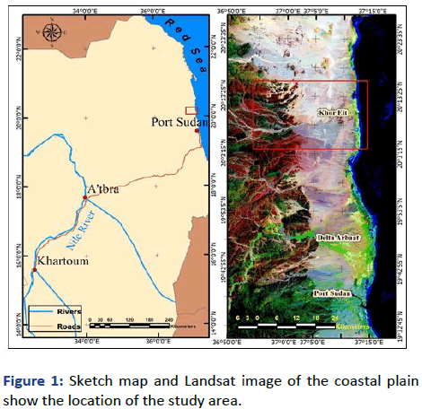
Figure 1: Sketch map and Landsat image of the coastal plain show the location of the study area.
The Sudanese coastal plain is about 740 km long, generally 20 km wide but increasing to 40 km at the Halaib area on its northern edge and to 50 km at Tokar Delta in the south. The coastal plain generally has gentle slope topography; it lies between the Red Sea shore and the Red Sea hills to the west. The coastal plain is predominantly made of integration of marine and continental materials.
In the previous studies regards the evolution of the Red Sea coastal plain, the overlain sediments have been divided into a pre-rift, syn-rift and post-rift sequences. This classification is not therapy strong evidence of rifting phases and related sedimentary facies [2].
The most significant stratigraphic studies in the coastal plain come as a result of works of Carella and Scarpa. As geological results of the AGIP exploration. They described the lithostratigraphy and bio-stratigraphy of surface and subsurface of the area. In 1965, Sestini gives an outline of the cenozoic sedimentary succession of Khor Eit, he described the major stratigraphic units in term of lithology, structures and depositional environments. Bunter and Abdel Magid described the stratigraphy, petroleum geological evolution and petroleum geochemistry of the Sudanese Red Sea.
From the literatures review, the litho-stratigraphic units are classified as: Pre rift sediments started during midcretaceous time including Mukawar and Hamamit formations in continental depositional environment. Syn rift sediments consist of Maghersum, Khor Eit and Abu Imama formations has been deposited in shallow marine environment. Post rift sediments of miocene-pliocene consist of Dungunab formation and the overly upper clastic group [3].
Objectives of the study
The overall objective of this study is to investigate the rifting phases and their evidences from the exposed outcrops at Khor Eit area north of Port-Sudan town making an allowance for the geological and structural setting as guide for to understand the rifting phase in the Red Sea coast of Sudan.
Methods of Investigations
In this study; office and field investigations were conducted to convince the goals of the study including: Remote sensing and GIS applications, field survey and the used of satellite gravity data for to confirm subsurface structures [4].
The remotely sensed and GIS investigations based on the available satellite imageries of the optical multi-spectral data of the Landsat 8 OLI and Sentinel radar images, which will be directed to identify different lithological units as well as defining major structural patterns. Furthermore, digital image processing and spectral analysis will be carried in order to map different litho-stratigraphic units by distinguishable spectral signatures. The digital image enhancement will be helping in structural features delineation such as regional faulting and major fractures.
The geological mapping was conducted in helps of remote sensing data and field survey during which different stratigraphic units were identified, since the litho-stratigraphic facies have been studded to identify the depositional characteristics. Some geological sections were built to categorize the field correlation between different stratigraphic units [5].
Structural documentations had been taken during the field survey including; the measures of strike and dips for the strata, faults/fractures orientations and their dipping in addition to identification of some geological sections showing the structural signs in outcropping rocks.
The satellite gravity data obtained from university of California-San Diego Web. 1-minute grids in ASCII XYZ-format, the extracted topography and gravity data from global, latitude (range is ± 80.738, topography, V19.1 and gravity, V29.1). The success of the gravity method depends on the different earth materials having different bulk densities (mass) that produce variations measuring gravitational field. The data were processed to remove all these predictable effects. In this investigation; the Bouguer Gravity (BG) anomalies, the separated (Residual) Gravity Anomalies (RGA) and the Second Vertical Derivatives (SVD) were used to detect the sub-surface geological configurations and structures [6].
This investigation integrates the geological, structural and geophysical finding for recognizing and understanding the rifting phases at Khor Eit exposed area at the coastal plain (as key area) to be as guide for understanding and identification of the rifting phases along the Red Sea coast.
Geological Setting
The study area characterized by the existence of subsurface and exposed sedimentary units extending from the outcropped crystalline basement to off-shore of the Red Sea coast. The thickness of the sedimentary sequence is gradually increasing to about 4,000 meters at the coastline. The geological column at Khor Eit area including from old to young: Basement complex, Maghersum formation, Khor Eit formation, Abu Imama formation, Dungunab formation, upper clastic group, pleistocene reefs and then alluvial and aeolian deposits (Figures 2 and 3) [7].
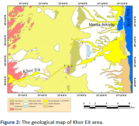
Figure 2: The geological map of Khor Eit area.
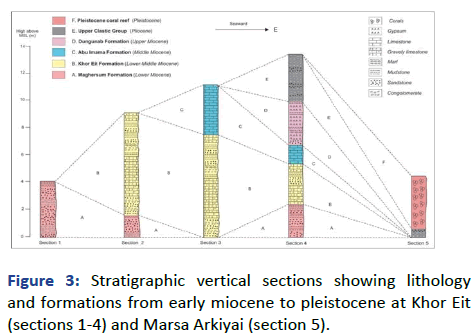
Figure 3: Stratigraphic vertical sections showing lithology and formations from early miocene to pleistocene at Khor Eit (sections 1-4) and Marsa Arkiyai (section 5).
Maghersum formation is the oldest sedimentary outcrops which referred to the syn-rift depositional phase. The Maghersum formation in the study area is exposed along the banks of Khor Eit and consists essentially of inter-bedded coarse sandstones and claystones. Caraella and Scarpa, recommended as lower-middle miocene age. Different geological sections were investigated consisting of different geological units. Paleo channels are recognized in Magersum formation running to the north direction (Figure 4) [8].
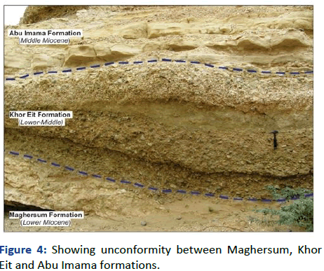
Figure 4: Showing unconformity between Maghersum, Khor Eit and Abu Imama formations.
Khor Eit formation is forms of inter-bedded sands and gravels, with subordinate argillaceous and sandy to nodular limestone. It shows lateral lithological variations with fossiliferous and coralline inter-beds. The unit lies between the lower clastic-units of Maghersum formation and the upper carbonate unit of Abu Imama formation.
Abu Imama formation mainly contains coralline and oolitic limestone have been deposited in shallow marine environment. The fossils content of Abu Imama carbonates indicate early to dominantly middle miocene age. The carbonate rocks of Abu Imam formation indicate large transgression stage of the sea level [9].
Dungunab formation set unconformably on the Abu Imama formation and overlain by the upper clastic group and pleistocene reef limestone. The formation is suggested to be of post middle miocene age. The formation includes massive gypsum deposit and salt rock inter-bedded with anhydrite, marl, mudstone and sandstone. The domination of evaporates indicates the lagoon environment within gradually regression stage.
Pleistocene coral reef buildups of inter-bedded with marls and mudstone of lagoonal to sabkha environment. They represent as reef terraces along the coast. More recent lagoon and shallow reef environments were recognized. In the study area the reefs represent well defined ridges aligned parallel to the coast which unconformably overlain the upper clastic group at Marsa Arkiayi at about 10 km to east of the area. The locations of the sections are shown on the geological map [10].
Structural Investigations
Structural investigation was carried out to examine the structural events controlling the setting of sedimentary units at Khor Eit area. The brittle deformation in the forms of fault and tectonic joints, it’s pristine and well preserved in rock units.
Structural Setting
Sedimentary structures in the Khor Eit area include bedding planes, unconformities and cross beddings in sedimentary rocks. Bedding planes are generally sub-horizontal to gently dipping to the east and to northeast. The exposed geological sections are dominated by brittle structures (faults and joints) which strongly manifest the rift configuration in which the dominant strikes of the strata are in N-S direction where the general dipping are to the east direction (Figure 5). The circular plot of readings of normal faults and reverse faults recognized in outcrops are presented in Figure 6 [11].
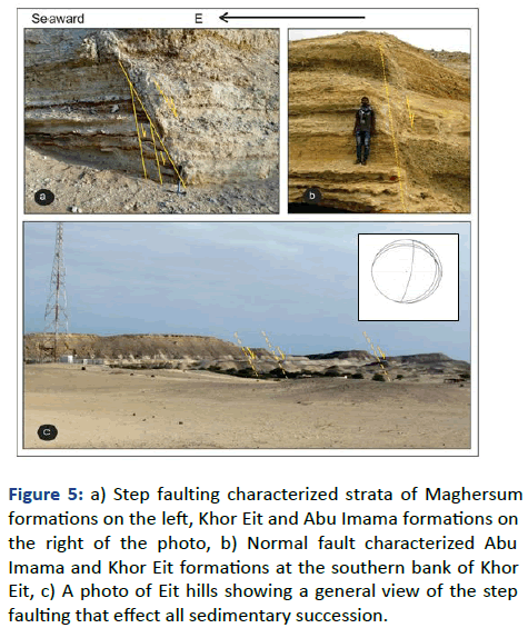
Figure 5: a) Step faulting characterized strata of Maghersum formations on the left, Khor Eit and Abu Imama formations on the right of the photo, b) Normal fault characterized Abu Imama and Khor Eit formations at the southern bank of Khor Eit, c) A photo of Eit hills showing a general view of the step faulting that effect all sedimentary succession.
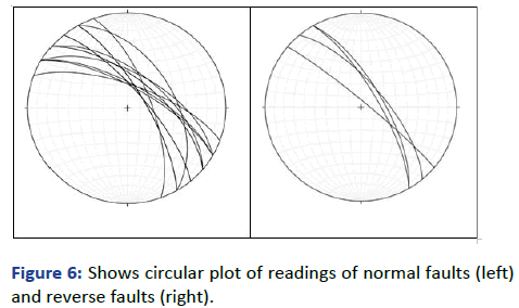
Figure 6: Shows circular plot of readings of normal faults (left) and reverse faults (right).
Paleo-Stress Analysis
Analysis of geological structure (such as faults sense of movement, joints, fold axes, etc.) in which the determinations of the stress field are essential for understanding the evolution and the tectonic processes behind such structures.
Paleo-stress analysis refers to various methods which attempt to determine a regional stress tensor consistent with existing geological structures. Different methods for estimating stress tensors have been determined from fault populations. The technique is based on several theoretical assumptions. Palaeostress analysis and subsequent determination of palaeo-stress field were conducted in several areas of the Red Sea rift. However, the Sudanese sector of the Red Sea Rift (RSR) remains unstudied; this work represents the first attempts to provide data of the palaeo-stress field.
Data pertaining to particular fault includes the fault plane orientation, slip direction and sense of slip, as well as location and character of fault attributes. The sense of slip (striation) indicates the direction of fault movement. The data relevant to the fault movement is used to calculate the paleo-stress tenser, which indicate the stress orientation relative to kinematic movement of a fault [12].
There are many different methods of direct graphical stress inversion; such as the right dihedral and PBT methods. Based on the Right Dihedral Method (RDM); superimposing all dihedral progressively narrows down the areas of compression and extension and the orientation of the principal stress axes is located. The data were collected from eight semi vertical faults and of joints in different location in the study area. These readings were entered into the Win-tensor program (Figure 7).
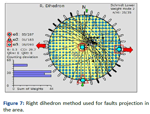
Figure 7: Right dihedron method used for faults projection in the area.
The inversion results show the value of maximum stress axis (σ1) as 85/287 (σ1vertical) ,while value of shear stress axis (σ2) is 1/183 and the value of minimum stress axis (σ3) is 5/93, σ2 and σ3 are horizontal. The orientation of the principal stresses fits perfectly the Andersonian model for normal fault and the ratio of the principal stress differences value (R) is 0.3 typical of normal fault. The obtained stress tensor supports an extensional regime in the study area which is in accordance with pattern of graben and horst frequently observed in similar environment.
The P-B-T method (PBT) is a kinematic analysis that in strict sense yields strain axes rather than stress axes. After inverting the data via PBT, we obtained a σ1 84/224, σ2 0/184 and σ3 6/44 and R of 0.5; a value of normal fault. This result is quite similar to those of the RDM (Figure 8).
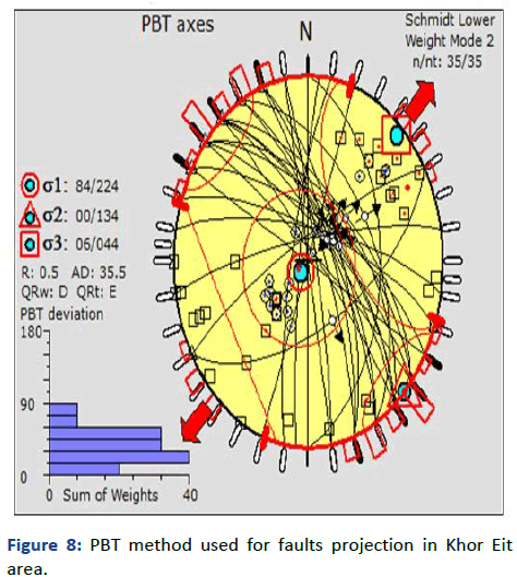
Figure 8: PBT method used for faults projection in Khor Eit area.
Compiled the data gained from the paleo-stress analysis with the geological field observations, in the first phase of rifting the main faults and major fractures system are in N-S and NW-SE trends as extensional fractures.
This findings are confirms by the direction of the paleocurrent of valleys that preserved in Maghersum, Khor Eit and Abu Imama formations. In the second phase of rifting the fractures/faults system are oriented in NE-SW, EW directions.
The paleo and recent stream currents in Dungunab formation and the upper most formations are parallel to the faults and fractures systems in these directions.
Satellite Gravity Investigation
The satellite gravity data were processed to measures the variations in the earth’s gravitational field caused by differences in density of sub-surface rocks. It’s used as important tool for delineating the structural manifestations of the rift.
The resulted fractures from the terrains collision during the Pan African era and during the Red Sea rifting were detected from the gravity alignments of Bouguer anomaly (Figure 9).
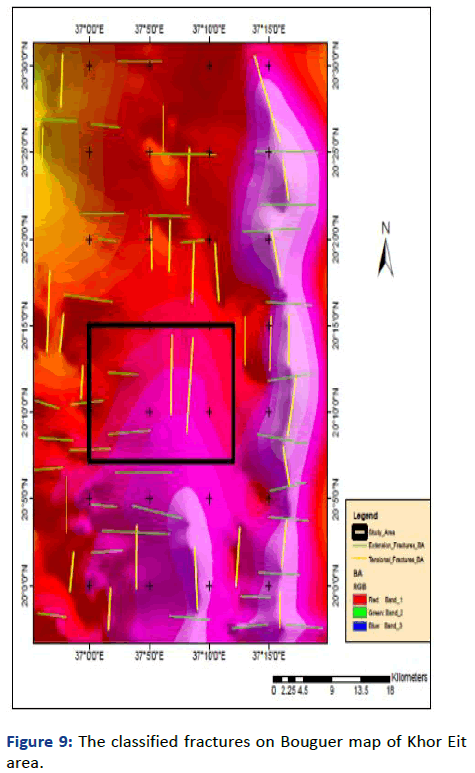
Figure 9: The classified fractures on Bouguer map of Khor Eit area.
Gravity separation is very sensitive since the oceanic crust is very thin due to nature of the passive margins, also due to the inherited tectono-structural complexity of the Red Sea. The rift events activities including basaltic eruptions lead to increase the density of rocks. The high density anomaly (in red) reflects the occurrences of high density rocks where the low density anomaly (in blue) is refer to low density sediments.
The second vertical derivative processing choices on to emphasis the fractures complexity nature to disclose the episodes of rifting fractures including; tensional, extensional fractures and their companied volcanicity in these open fractures and its signature (Figure 10).
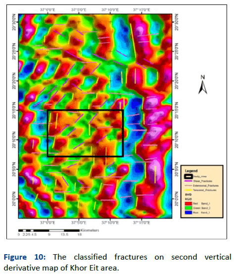
Figure 10: The classified fractures on second vertical derivative map of Khor Eit area.
The interpretation was constrained by the agreed principal ideas regarding the older tectonic eras and the rifting phases; since our aim to resolve the spatial and temporal events that control lithological distribution and its mutual relationship. From the Figures 8 and 9, three alignments features were recognized; the N-S and NW-SE alignments parallel to the general Red Sea trend, the perpendicular E-W and the NE-SW alignments.
The satellite gravity geophysical findings support the structural findings which delineate three main faults regimes; in N-S direction parallel to the sea trend, the crossing E-W fault system and the NNE-SSW fractures which are also appears in the exposed basement rocks to the west as shear fractures.
Khor Eit area represents well exposed oligocenemiocene terrestrial and shallow marine sediments along the sea coast overlying unconformably the basement rocks. The division of these sediments as pre-rift, syn-rift and post-rift sequences is not precisely where the rifting is still active. Instead of it the term pre, syn and post subsidence is more accurate to classify the bulk of sedimentary sequences.
The geological column in Khor Eit area including: Basement complex, Magarsam formation, Kor Eit formation, Abu Emama formation, Dongonab formatiom, upper clastic group, pleistocene reefs and then alluvial, aeolian and sabkha deposits.
Structurally the area was subjected to the two extensional faulting in N-S and NW-SE parallel to the general rifting trend of the Red Sea and then in E-W and NE-SW direction a crossing the rift orientation. These lead to forms step faults with main component toward the sea and then it had been alienated in to horst and graben structures in the second phase.
The satellite gravity reflecting the occurrences of high density rocks as horst parts where the low density parts are attributed to the grabens fill by thick sediments. The geophysical findings support the structural findings that identify the main faulting regimes in N-S and in E-W trends. Other NE-SW fractures are recognized in the Second Vertical Derivatives (SVD) at the old basement area it may be attributed to uncounted latest shear event.
The study conclude that the rifting started first with N-S, NWSE fractures since the deposition of Maghersum, Khor Eit and Abu Imama formations, which evidence by the existence of the paleo-streams in the same directions. The second phase is the subsidence phase after the deposition of Dungonab and upper clastic sediments formations that made the paleochannel direction change toward the sea in E-W, NE-SW directions.
This complicated depositional and structural setting will make the oil exploration is very difficult via the understanding of structural patterns and rift model is of great importance.
The authors are greatly acknowledged the faculty of petroleum and minerals, Al Neelain University Sudan, for their finance and support the field works through the student graduation training program.
Citation: Elsheikh AEM, Hamed BO, Ibinoof MA, Ali OMM, Mukhtar MI (2024) The Investigation of Rifting Phases and their Evidences from the Exposed Outcrops at Khor Eit Area, as Guide for Understanding the Rifting Phases in the Red Sea Coast of Sudan. Adv Appl Sci Res. 15:48.
Copyright: © 2024 Elsheikh AEM, et al. This is an open-access article distributed under the terms of the Creative Commons Attribution License, which permits unrestricted use, distribution, and reproduction in any medium, provided the original author and source are credited.